
Saturday 29th October, cruise
JC142 left Santa Cruz, Tenerife, bound for Tropic Seamount, some 300 nautical
miles SW of the Canary Islands. We spent
the preceding day on a geology field trip on Mount Teide, the islands tallest
volcano. Teide is the 3rd highest volcano on Earth, rising almost 8km from the
deep seafloor. The evolution of Teide and Tenerife has echoes in the formation
of Tropic Seamount. On Tenerife we walked into the huge caldera and looked at
the more recent peak which forms the summit of Teide. We examined cinder cones,
lava flows and crystals, and discussed the distinction between minerals and
life; crystals reproduce their unit cell structure and grow from chemical and
energy gradients; the basic building blocks of life do much the same.

The
RRS James Cook preparing to sail for Tropic Seamount. Our banner says it all,
“Securing critical marine minerals for a sustainable low-carbon future”.
Ferromanganese crusts forming on some ancient seamounts are rich in rare metals
that are essential to making ‘green’ technologies like solar panels and wind
turbines.

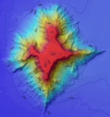 |
Tropic
Seamount is one of a small province of 100 million year old underwater
volcanoes SW of the Canary Islands.
|
Tropic Seamount started life about 120
million years ago, just after the Atlantic Ocean was born. At that time, the
Atlantic was only as wide as the Red Sea, and Tropic Seamount was a
palm-fringed volcanic island surrounded by a coral reef. Over the millennia,
Tropic Seamount slowly sank beneath the waves. As it did so, the sea eroded the
peak, giving it a flat top. Earthquakes shook the volcano causing its sides to
collapse. We see the result today, a star-shaped, flat-topped seamount of the
type called a gyot. Although much diminished from its former grandeur, Tropic
Seamount is still 3km high and covers twice the area of the Isle of Wight.
The aim of our mission here is to
understand what controls the formation and precipitation of cobalt-rich crusts
on seamounts like Tropic. These crusts are potentially rich resources for scarce
elements that are critical to new technologies and especially those that are
used in low-carbon energy production like solar panels and wind turbines. While
some seamounts are rich in these crusts, extraction of the minerals is also
harmful to the immediate environment and part of our work is to study the
potential impact of deep-sea mining.
During our mission we will be deploying the
latest technology. The ship will use its sonar systems to map the seamount at a
resolution of 25m2. This provides a base map and shows us where the
hard and soft rock and sediment is distributed. We use this information to map
the seafloor with our robotic submarine, Autosub6000. This yellow submarine is
torpedo-shaped and is sent off on its own for 24 hours at a time. The images it
brings back reveal the seafloor in great detail – with a resolution of 1m2
for the bathymetry and 25 cm2 for the acoustic sidescan sonar pictures,
showing minute details of the crusts and sediment pockets. Once these images
are back on board, we chose sites to dive on with our remotely operated
submarine, Isis. This vehicle hangs
on a cable and we control it from a room in the ship.
 |
| Ella launches the Autosub6000 robot submarine from the stern of the RRS James Cook. Autosub6000 is autonomous and maps the seafloor during 24-hour missions on its own. The sub can dive to 6000m below the surface and make sonar images of the seafloor in astounding resolution and clarity. |

The
remotely operated vehicle ‘Isis’ is launched over the side of the RS James
Cook. This robotic submarine is controlled from a room onboard. We use it to
drill and collect samples of the crusts from the seafloor. We also use ‘Isis’
to conduct experiments to simulate the effects of seafloor mining and the
potential impact such activity might have on the surrounding environment. Isis
can dive to 6500m below the surface and operate for days without a break.

Inside
the ROV 'shack' – operating the ROV is a complex task and requires the pilots and
scientists to work closely together.

The
lander is placed on the seafloor by the ROV and waits for the first of our
experiments to generate a sediment plume.

The
ROV holds a hose as it blows a sediment plume in the water up-stream from the
lander. This is the first time every that an experiment has been done to
simulate the potential effects of disturbance from seabed mining on the
surrounding environment. It is widely thought that sediment plumes can spread
far and damage vulnerable animals such as sponges and corals. We aim to explore
this by conducting small-scale experiments 1000m below the surface on the
seabed.
One of our aims is to explore the potential
effects of deep-sea mining on the surrounding environment. For this we have
built a seafloor observatory, called a seabed lander, to image and measure dust
plumes as they drift across the top of the seamount. The lander is deployed by
‘Isis’ which generates sediment
plumes in the water. Modelling and monitoring of the currents allows us to
predict how fast and how far the plumes will drift. We position the ROV
up-stream from the lander, at different distances, and generate the plumes over
a period of several hours. We plan to use the Autosub6000 to swim though the
plumes at a distance of 1km. This information will be combined with an
ecological study of the distribution of the animals most vulnerable to sediment
disturbance to assess the potential impact of seafloor mining.
While modern
civilization needs rare elements found in these deep-sea mineral deposits to
function and reduce our overall planetary environmental impact, we have a duty
to assess the impact that extracting these minerals may have on the immediate
and local environment. These data will help shape future regulations and laws
around deep-sea mining.
tropic seamont belongs to Morocco not to the canarian island
ReplyDelete